At AdanGIS, we develop customized GIS solutions that adapt to each client, integrating web tools, databases, interactive viewers, and automation of geospatial processes. We transform ideas into functional platforms.
Interactive web applications for visualizing and querying spatial data.
Public or private viewers with filters, analysis, layer download, etc.
Adapted for mobile devices and multi-user access.
Complete GIS systems developed from scratch, according to the client's needs.
Integration with external databases (SQL, PostgreSQL/PostGIS, Access, etc.).
Features such as login, dashboards, data editing, alerts, etc.
Scripts and tools that automate analysis, map generation, or periodic reports.
Ideal for project monitoring, environmental reports, production control, etc.
Connection of GIS platforms with CRMs, ERPs, IoT sensors, external APIs, etc.
Example: view incidents on the map that come from a call center or environmental sensors.
Design and implementation of efficient spatial databases (PostGIS, SpatiaLite, GeoPackage).
Optimization of structures for large volumes of geographic data.
Field data capture apps (Android/iOS) synchronized with GIS servers.
Custom forms, offline geolocation, photos, QR codes, etc.
Applications created with tools like Leaflet, OpenLayers, QGIS Server, or GeoServer.
Exposition of WMS/WFS services or REST APIs for internal or external use.
Cross-referencing spatial data with statistical or predictive models (Machine Learning).
Mobility studies, market analysis, detection of complex spatial patterns.
Architecture of GIS systems on cloud servers, Docker, load balancing, etc.
Ideal for projects with many users or large amounts of data.
Services for businesses or administrations that want to implement or improve their customized GIS systems.
Courses, workshops, or technical assistance in proprietary developments.
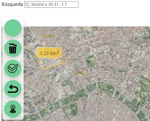
GIS Viewer
Copyright 2026 adanair.com