Extensive experience in
thermographic mapping
and specialized imaging.
Advanced tools
and customized web viewers
Highly qualified professional team
with ongoing training.
OUR SERVICES
ABOUT US
YEARS OF EXPERIENCE
Satisfied Customers
To offer our clients a quality service with an immediate response that meets their needs with an excellent quality/price ratio.
To achieve reliable, durable, efficient, and safe projects, with the aim of ensuring the success of our clients' projects.
The main asset of our company is the people who make it up; they are the ones who, with their dedication and specialization, allow us to continue growing.
Professionally qualified human team, equipped with the latest technology, to better offer and adjust the project.
THERMAL
AdanGIS offers specialized services in thermographic mapping, infrared and NIR imaging, leak and contamination detection, video and mosaic production, custom web viewers, interactive maps, marine monitoring, and aerial photography, combining advanced technology with extensive experience.
AdanGIS offers customized analysis and high-precision geospatial data capture through aerial photography and digital models with quality comparable to commercial LiDAR.
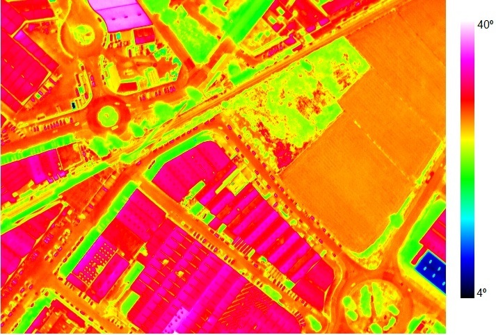
Georeferenced thermal orthophotos allow for the quick identification of anomalous temperature areas in geothermal regions, facilitating scientific studies and the detection of leaks or failures in thermal facilities.
FLIGHTS
DEVELOPMENT GIS/GIS
Custom auto-updating viewers.
Automatic tile generation.
GIS software.
We combine and analyze location, risk, and distance data, offering accessible visualizations for users with no experience, integrated into custom applications and web viewers.
Creation of specialized maps for sectors such as precision agriculture, forest management, urban planning, and mining. Customized according to your needs.
We model networks, optimize routes, analyze watersheds, and assess territorial risks for efficient space management.
We offer courses and consultancy for companies and organizations that want to enhance their management of geospatial data.
We create apps for the collection and consultation of GIS data in the field, optimizing management and access to information in real time.
Copyright 2026 adanair.com